The World's Strangest Time Zone Borders
Time zones should follow logic. They should be neat, orderly lines on a map. But they are not.
Because time zones are shaped by politics, history, and stubborn local preferences, some borders are downright bizarre. There are islands 2 miles apart separated by 21 hours. There are towns where you can celebrate New Year's Eve twice. There are borders where crossing the street means changing your watch.
This guide explores the world's strangest time zone borders.
Use the free time zone converter here →
The Short Answer: Why Borders Get Weird
Time zone borders are strange because they follow political and economic convenience, not geography. When countries choose their own offsets, neighbors can end up hours apart.
| Border | Difference | Why It's Strange |
|---|---|---|
| Diomede Islands | 21 hours | 2 miles apart, different days |
| China–Afghanistan | 3.5 hours | China's single zone vs Afghanistan's half-hour |
| Arizona–Navajo Nation | 1 hour (seasonal) | Nested time zones |
| India–Nepal | 15 minutes | Smallest difference |
| Kiribati | 26 hours from Baker Island | Moved the date line |
| Lloydminster | 1 hour (seasonal) | Follows Alberta, not Saskatchewan |
The Diomede Islands: 21 Hours Apart, 2 Miles Away
The Geography
The Diomede Islands sit in the Bering Strait between Russia and Alaska. Big Diomede belongs to Russia. Little Diomede belongs to the United States. They are barely 2.4 miles apart [citation:11].
| Aspect | Big Diomede | Little Diomede |
|---|---|---|
| Country | Russia | United States |
| Time Zone | UTC+12 | UTC−09 |
| Population | 0 | ~83 |
| Nickname | Tomorrow Island | Yesterday Island |
The Time Difference
Because the International Date Line runs between them, the islands are separated by 21 hours (or 20 hours during summer, when both observe daylight saving) [citation:11].
| Moment | Little Diomede (US) | Big Diomede (Russia) |
|---|---|---|
| Same instant | Saturday 5:00 PM | Sunday 2:00 PM |
When it is Saturday afternoon on Little Diomede, it is already Sunday afternoon on Big Diomede.
The Icy Walk
In winter, the Bering Strait freezes over. In theory, you can walk from the US to Russia — and from Saturday into Sunday — in just a few minutes [citation:11].
Why This Exists
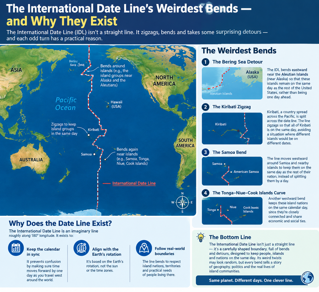
The date line runs between the islands because the US and Russia are on opposite sides of the calendar. The islands are a natural boundary point.
The China–Afghanistan Border: 3.5 Hours in One Step
The Geography
China's westernmost province, Xinjiang, shares a tiny border with Afghanistan's Wakhan Corridor [citation:16].
| Aspect | China | Afghanistan |
|---|---|---|
| Time Zone | UTC+8 (single zone) | UTC+4:30 |
| Difference | — | 3.5 hours |
The Single Zone Problem
China spans five geographic time zones but uses only one: Beijing Time (UTC+8) [citation:16]. This creates a massive jump at the border.
| Location | Local Time for 12:00 UTC |
|---|---|
| Beijing | 8:00 PM |
| Western Xinjiang | 8:00 PM (clock) |
| Afghanistan | 4:30 PM |
The Unofficial Fix
In practice, many people in western Xinjiang use an unofficial UTC+6 time, which better matches the sun. This can make finding out the "real" time incredibly confusing [citation:16].
The Result
Crossing this remote border means adjusting your watch by 3.5 hours — one of the largest time jumps at any border on Earth.
The Nested Time Zones of Arizona
The Layered Problem
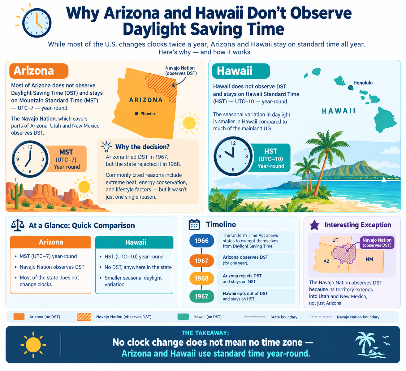
Arizona does not observe daylight saving time. The Navajo Nation within it does. The Hopi Reservation inside the Navajo Nation does not [citation:1].
| Area | DST? | Summer Offset |
|---|---|---|
| Most of Arizona | No | UTC−07:00 |
| Navajo Nation | Yes | UTC−06:00 |
| Hopi Reservation | No | UTC−07:00 |
Driving Through
In summer, driving through this region means repeatedly changing your clock. You can go from Arizona time (no DST) to Navajo time (DST) to Hopi time (no DST) and back again [citation:16].
The Same-Street Problem
Moenkopi (inside the Hopi Reservation) and Tuba City (part of the Navajo Nation) are effectively the same city. You can go forward an hour simply by crossing the road [citation:16].
The India–Nepal Border: 15 Minutes
The Smallest Difference
India uses UTC+05:30. Nepal uses UTC+05:45. The difference is just 15 minutes [citation:1].
| Country | Offset |
|---|---|
| India | UTC+05:30 |
| Nepal | UTC+05:45 |
| Difference | 15 minutes |
Why Nepal Chose 45 Minutes
Nepal moved to UTC+05:45 in 1986, partly to align with the meridian through Gauri Shankar mountain and partly to assert independence from India [citation:8].
The Border Experience
Crossing from India to Nepal means adjusting your watch by just 15 minutes — one of the smallest time zone changes possible on Earth.
Kiribati: The Country That Moved the Date Line
The Problem
Before 1995, the International Date Line ran through the middle of Kiribati, splitting the country into two different calendar days [citation:4].
| Aspect | Before | After |
|---|---|---|
| Date Line | Through Kiribati | 2,400 km east |
| Phoenix Islands | UTC−11:00 | UTC+13:00 |
| Line Islands | UTC−10:00 | UTC+14:00 |
The Fix
In 1995, Kiribati moved the date line so the entire country could share the same date [citation:4][citation:14].
The Result
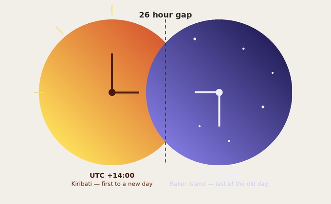
Line Islands now use UTC+14:00, the easternmost time zone on Earth. They are the first places to see each new day [citation:9].
The 26-Hour Gap
The Line Islands are 26 hours ahead of Baker Island (UTC−12:00), creating the largest time zone difference on the planet [citation:9].
Lloydminster: The Border City
The Geography
Lloydminster sits directly on the border between Alberta and Saskatchewan, Canada. It is the country's only "border city" with a single municipal government in both provinces [citation:1].
| Province | DST? |
|---|---|
| Alberta | Yes |
| Saskatchewan | No |
The Solution
To keep the city unified, Lloydminster follows Alberta time year-round. The Saskatchewan side does not change clocks with the rest of Saskatchewan [citation:1].
The Result
Half the year, Lloydminster is one hour off from the rest of Saskatchewan.
Tweed Heads and Coolangatta: Two New Years
The Twin Towns
Tweed Heads (New South Wales) and Coolangatta (Queensland) merge seamlessly on the Australian border [citation:16].
| State | DST? |
|---|---|
| New South Wales | Yes |
| Queensland | No |
The New Year's Trick
You can celebrate New Year's Eve twice: start in Tweed Heads, then walk into Coolangatta an hour later and do it again [citation:16].
Other Strange Borders
| Border | Difference | Why |
|---|---|---|
| Norway–Russia–Finland | Up to 4 hours | Three zones meet at one cairn [citation:3] |
| Pakistan–India | 30 min (varies) | DST creates shifts [citation:8] |
| Bangladesh–India (east) | 30 min | India's northeast is wrapped around Bangladesh [citation:8] |
| Eucla, Australia | 45 min | Remote town uses own offset [citation:16] |
| Chatham Islands | 45 min | Uses UTC+12:45 [citation:4] |
Quick Reference Card
━━━━━━━━━━━━━━━━━━━━━━━━━━━━━━━━━━━━━━━━━━━━━━━━━━━━━━━━━━
   WORLD'S STRANGEST TIME ZONE BORDERS — CHEAT SHEET
━━━━━━━━━━━━━━━━━━━━━━━━━━━━━━━━━━━━━━━━━━━━━━━━━━━━━━━━━━

DIOMEDE ISLANDS:
  2.4 miles apart, 21 hours difference
  Big Diomede (Russia) = Tomorrow Island
  Little Diomede (US) = Yesterday Island
  Can walk between them on ice

CHINA–AFGHANISTAN:
  3.5 hour jump at border
  China uses single zone (UTC+8)
  Afghanistan uses UTC+4:30
  Unofficial UTC+6 in Xinjiang

ARIZONA NESTED ZONES:
  Arizona (no DST) → UTC−07:00
  Navajo Nation (DST) → UTC−06:00
  Hopi Reservation (no DST) → UTC−07:00
  Same city can have different times

INDIA–NEPAL:
  15 minutes difference
  India: UTC+05:30
  Nepal: UTC+05:45

KIRIBATI:
  Moved date line in 1995
  Line Islands: UTC+14:00
  26 hours ahead of Baker Island

LLOYDMINSTER:
  Border city in Alberta/Saskatchewan
  Follows Alberta time year-round

TWEED HEADS / COOLANGATTA:
  Celebrate New Year's Eve twice
  Walk across border, do it again

GOLDEN RULE:
  Time zone borders follow politics, not geography.

━━━━━━━━━━━━━━━━━━━━━━━━━━━━━━━━━━━━━━━━━━━━━━━━━━━━━━━━━━
         Check live conversions at: /timezone-converter
━━━━━━━━━━━━━━━━━━━━━━━━━━━━━━━━━━━━━━━━━━━━━━━━━━━━━━━━━━
Frequently Asked Questions
What is the strangest time zone border in the world?
The Diomede Islands are the most extreme: two islands 2.4 miles apart with a 21-hour time difference, meaning they are on different calendar days [citation:11].
Why are the Diomede Islands 21 hours apart?
The International Date Line runs between them. Big Diomede (Russia) is on one side, Little Diomede (US) is on the other, creating a nearly full-day difference [citation:11].
What is the time difference between China and Afghanistan?
China uses UTC+8, while Afghanistan uses UTC+4:30. The difference is 3.5 hours at their shared border [citation:16].
Why does Arizona have nested time zones?
Arizona does not observe DST, but the Navajo Nation within it does. The Hopi Reservation inside the Navajo Nation does not. This creates three layers of time [citation:1].
What is the smallest time zone difference at a border?
The India–Nepal border has a difference of just 15 minutes. India uses UTC+05:30 and Nepal uses UTC+05:45 [citation:1].
Why did Kiribati move the International Date Line?
Before 1995, the date line split Kiribati into two different calendar days. The government moved it so the entire country could share the same date [citation:4].
Can you celebrate New Year's Eve twice in one night?
Yes. In Tweed Heads and Coolangatta, Australia, you can celebrate in New South Wales, walk across the border to Queensland, and celebrate again an hour later [citation:16].
What is special about Lloydminster?
Lloydminster sits on the Alberta–Saskatchewan border. It follows Alberta time year-round, so the Saskatchewan side does not change clocks with the rest of the province [citation:1].
Where do three time zones meet?
Norway, Finland, and Russia meet at Treriksrøysa (Three-Country Cairn). The three countries observe different time zones, creating up to a 4-hour difference [citation:3].
Why do time zone borders get so strange?
Because they follow political and economic convenience, not geography. Countries choose offsets that suit their needs, and neighbors can end up hours apart.
Final Thoughts
Time zone borders are a perfect example of how human decisions shape the world. They bend, zigzag, and sometimes split communities in two. The Diomede Islands prove that geography means nothing when politics gets involved. The nested zones of Arizona show that even within a single state, time can be layered. And the tiny 15-minute gap between India and Nepal is a reminder that sometimes, the smallest differences cause the biggest confusion.
Three things to remember:
- The Diomede Islands are 21 hours apart. 2 miles, different days
- China's single time zone creates a 3.5-hour jump. At the Afghanistan border
- Arizona has nested time zones. Arizona, Navajo, and Hopi all differ
Check time zone conversions instantly → /timezone-converter
Tags: strangest time zone borders, Diomede Islands time difference, China Afghanistan time zone jump, Arizona Navajo Nation time zones, Nepal India 15 minute difference, Kiribati date line move, Lloydminster time zone, Tweed Heads Coolangatta time, bizarre time zone borders, time zone converter