The International Date Line's Weirdest Bends and Why They Exist
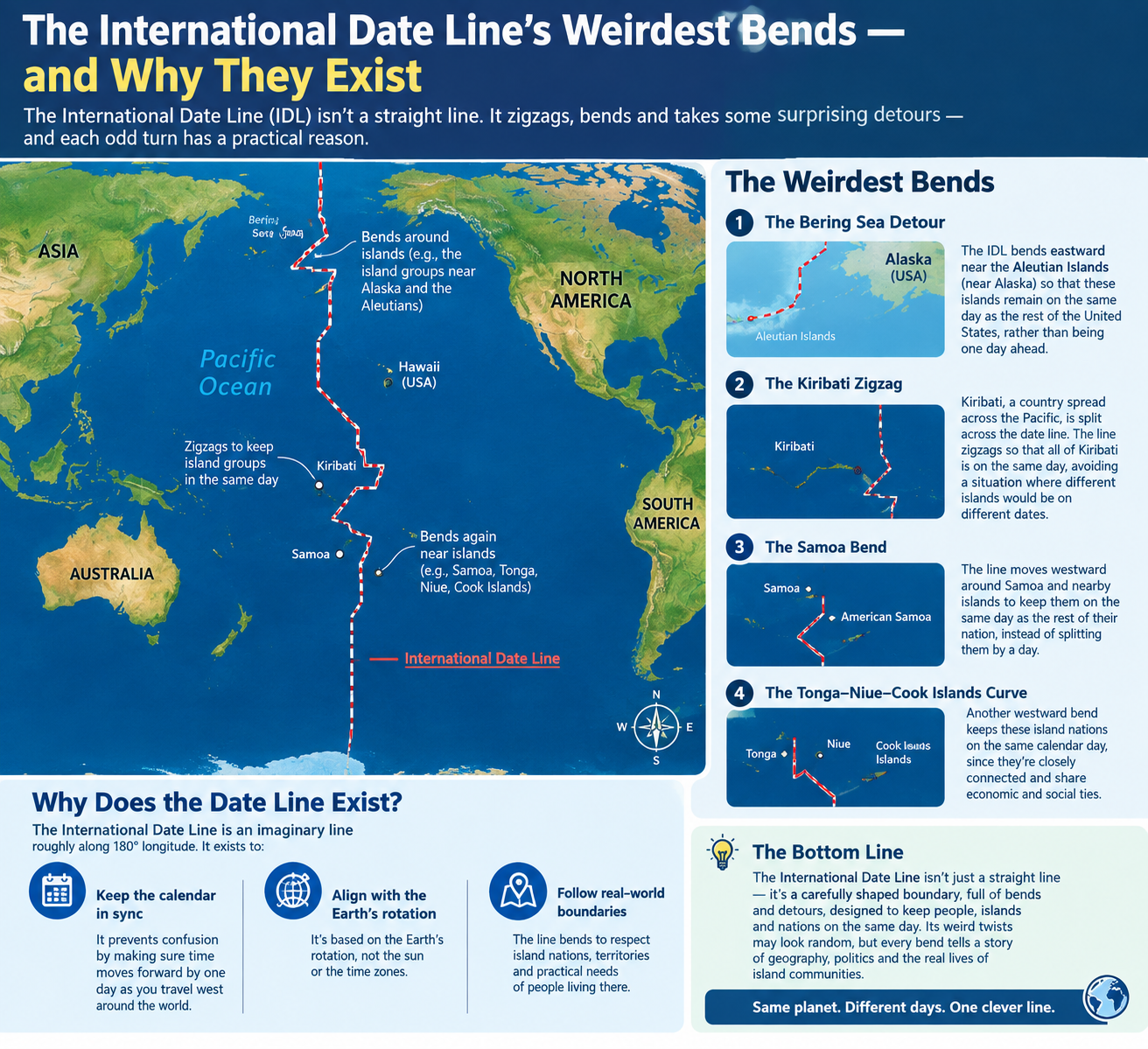
The International Date Line (IDL) is one of the strangest lines on any map. It is not a border, not a physical feature, and not even a straight line. It zigzags drunkenly down the middle of the Pacific Ocean, taking massive detours around tiny islands and veering east and west for reasons that have nothing to do with geography [citation:14].
Why? Because the date line exists to serve people, not to follow a meridian. And people are messy.
This guide explores the weirdest bends in the IDL and the political, economic, and practical reasons behind them.
Use the free time zone converter here →
The Short Answer: Why the Date Line Bends
The IDL roughly follows the 180° meridian, but it bends whenever a straight line would split a country, island group, or territory into two different calendar days [citation:7][citation:19].
| Reason for Bending | Example |
|---|---|
| Keep a nation unified | Kiribati |
| Align with trading partners | Samoa |
| Keep territory with parent country | Aleutian Islands (US) |
| Avoid splitting island chains | Fiji, Tonga |
| Follow political boundaries | Russia's Chukotka |
The core principle: It is better to bend the line than to force neighbors to live on different days.
The Biggest Detour: Kiribati
The Problem
Kiribati is an island nation of 32 atolls and one raised coral island, spread across a vast stretch of the central Pacific — about 3,900 kilometers from east to west [citation:1][citation:4].
Before 1995, the IDL ran right through the middle of the country, splitting it in two. The western Gilbert Islands were on one side, and the eastern Phoenix and Line Islands were on the other, creating a 23-hour difference within a single nation [citation:4][citation:6].
The Business Nightmare
| Problem | Impact |
|---|---|
| Government offices split | Two sides could only communicate on four days per week |
| Business confusion | Same country, different days |
| Administrative chaos | Documents dated differently |
The situation was unsustainable [citation:9].
The Fix: A 2,400 km Detour
In 1994, Kiribati decided to move the date line. They did it by skipping January 1, 1995 entirely in the eastern island groups [citation:4][citation:13].
| Change | Before | After |
|---|---|---|
| Phoenix Islands | UTC−11:00 | UTC+13:00 |
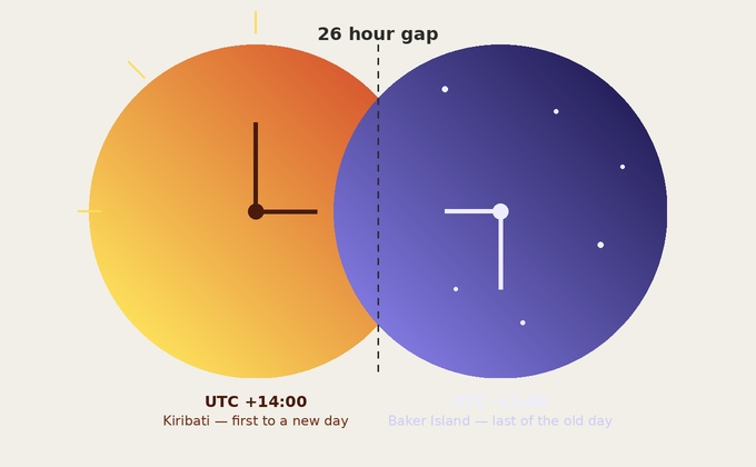
| Line Islands | UTC−10:00 | UTC+14:00 |
| Date line position | Through Kiribati | 2,400 km east |
The date line now takes a massive detour of over 1,500 miles around Kiribati's easternmost islands [citation:6][citation:10].
The Side Effect: First to See the New Year
Because the Line Islands now sit at UTC+14:00, Kiribati is the first country in the world to welcome each new year [citation:1][citation:4]. The easternmost island, Caroline Atoll (renamed Millennium Island), was the first landmass to see the year 2000 [citation:9][citation:11].
The Samoa Split: 101 Miles, 24 Hours Apart
The Geography
Samoa and American Samoa are separated by just 101 miles (163 km) of ocean [citation:6][citation:10]. Yet they are often a full day apart.
| Territory | Status | Side of IDL |
|---|---|---|
| Samoa | Independent nation | West (since 2011) |
| American Samoa | US territory | East |
The 2011 Change
Until 2011, both Samoas were on the east side of the date line, making them the last places in the world to welcome the new year [citation:6].
But Samoa's biggest trading partners were New Zealand and Australia, which are on the west side of the line. Doing business across a 23-hour gap was a headache [citation:6].
The Fix
In 2011, Samoa hopped to the west side of the date line, aligning with Australia and New Zealand. American Samoa stayed put [citation:6].
| Aspect | Samoa | American Samoa |
|---|---|---|
| Side of IDL | West | East |
| Trading partners | Australia, NZ | United States |
| New Year | First | Last |
| Time difference | Up to 25 hours | — |
Now, when it is Friday in Samoa, it is still Thursday in American Samoa [citation:10].
The Northern Bends: Russia and Alaska
Russia's Chukotka Peninsula
Heading south from the North Pole, the date line lurches east through the Bering Strait to keep the Chukotka Peninsula on the same day as the rest of Russia [citation:10][citation:14].
| Aspect | Details |
|---|---|
| Region | Chukotka, Russia |
| Reason | Avoid splitting Russia |
| Result | All of Russia on the same date |
The Aleutian Islands
The line then swings far west to lasso the Aleutian Islands into the same day as the rest of Alaska and the United States [citation:10][citation:14].
| Aspect | Details |
|---|---|
| Region | Aleutian Islands, Alaska |
| Reason | Keep with rest of Alaska |
| Result | US territory unified |
The quirk: Some Russians see the new year a full day before some Americans, even though they are neighbors across the Bering Strait [citation:10].
Other Notable Bends
Fiji and Tonga
The date line swings east so that Fiji, Tonga, and New Zealand's Kermadec Islands share the same date, while Samoa (after 2011) is one day ahead [citation:11].
Wallis and Futuna
French territory Wallis and Futuna stays on the same date as Fiji and Tonga, not split from its regional neighbors [citation:11].
The Philippines (Historical)
The Philippines once had a special arrangement with the date line due to its trade relations with Mexico. It was one of the exceptions to standard date line practice [citation:8][citation:11].
A Map of the Bends
| Region | Direction of Bend | Reason |
|---|---|---|
| Bering Strait | East | Keep Chukotka with Russia |
| Aleutian Islands | West | Keep with Alaska |
| Kiribati | East (huge) | Unify the nation |
| Samoa | East (2011) | Align with trading partners |
| Fiji/Tonga | East | Regional consistency |
Quick Reference Card
━━━━━━━━━━━━━━━━━━━━━━━━━━━━━━━━━━━━━━━━━━━━━━━━━━━━━━━━━━
   INTERNATIONAL DATE LINE BENDS — CHEAT SHEET
━━━━━━━━━━━━━━━━━━━━━━━━━━━━━━━━━━━━━━━━━━━━━━━━━━━━━━━━━━

WHAT IT IS:
  Imaginary line in the Pacific Ocean
  Roughly follows 180° meridian
  Not fixed by international law
  Bends to serve political/economic needs

WHY IT BENDS:
  • Keep nations on the same day
  • Align with trading partners
  • Avoid splitting island chains
  • Follow political boundaries

THE BIGGEST DETOURS:

KIRIBATI (1995):
  Moved line 2,400 km east
  Skipped Jan 1, 1995
  Now at UTC+14:00
  First to see New Year

SAMOA (2011):
  Hopped west of the line
  Aligns with Australia/NZ
  American Samoa stayed east
  101 miles apart, 24 hours difference

ALEUTIAN ISLANDS:
  Line swings west
  Keeps islands with Alaska

CHUKOTKA, RUSSIA:
  Line lurches east
  Keeps peninsula with Russia

THE QUIRK:
  Some Russians see New Year
  a full day before some Americans

GOLDEN RULE:
  The date line serves people, not geography.

━━━━━━━━━━━━━━━━━━━━━━━━━━━━━━━━━━━━━━━━━━━━━━━━━━━━━━━━━━
         Check live conversions at: /timezone-converter
━━━━━━━━━━━━━━━━━━━━━━━━━━━━━━━━━━━━━━━━━━━━━━━━━━━━━━━━━━
Frequently Asked Questions
Why is the International Date Line not straight?
The date line bends to avoid splitting countries and island groups into different calendar days. A straight line would create confusion for daily life and governance [citation:19].
Why does the date line detour around Kiribati?
Before 1995, the date line split Kiribati into two parts, creating a 23-hour difference within the country. The government moved the line over 2,400 km east so the entire nation could share the same date [citation:4][citation:6].
Why are Samoa and American Samoa on different days?
In 2011, Samoa moved to the west side of the date line to align with its trading partners, Australia and New Zealand. American Samoa stayed on the east side, aligned with the United States [citation:6].
Which country is first to see the New Year?
Kiribati, specifically the Line Islands at UTC+14:00, is the first country to welcome each new year [citation:4][citation:18].
What happens when you cross the International Date Line?
Crossing west, you add a day. Crossing east, you subtract a day. The time may stay similar, but the date changes [citation:14].
Is the date line fixed by law?
No. The International Date Line is not fixed by any international law or agreement. It bends to accommodate government and business interests [citation:10].
Why do the Aleutian Islands bend the date line?
The line swings west to keep the Aleutian Islands on the same day as the rest of Alaska and the United States [citation:10].
Why does the date line go east near Russia?
The line lurches east through the Bering Strait to keep Russia's Chukotka Peninsula on the same day as the rest of Russia [citation:14].
Can you really arrive before you left?
Yes. Flying from Tonga to Samoa, for example, takes about two hours but crosses the date line, causing passengers to arrive the day before they left [citation:11].
What is the biggest detour in the date line?
The detour around Kiribati, which extends over 2,400 kilometers (1,500 miles) east of the 180° meridian [citation:6].
Final Thoughts
The International Date Line is a perfect example of how time is a human invention, not a law of nature. It bends and zigzags not because of geography, but because of politics, economics, and the simple desire of nations to live on the same day.
Kiribati moved the line to unify its people. Samoa moved it to align with its trading partners. The Aleutian Islands stay with Alaska. These bends are not mistakes — they are solutions to human problems.
Three things to remember:
- The date line serves people. It bends to keep nations unified
- Kiribati has the biggest detour. A 2,400 km swing to unify the country
- Samoa and American Samoa are neighbors on different days. 101 miles apart, 24 hours apart
Check time zone conversions instantly → /timezone-converter
Tags: International Date Line bends, why IDL zigzags, Kiribati date line detour, Samoa date line change, Aleutian Islands date line, international date line map, date line around countries, UTC+14 Line Islands, international date line explained, time zone converter